
NEWS
Home Reef Gained 20 Acres of Land Waves Usually Erase
Tonga’s Home Reef added nearly 20 acres of lava by February 2026. The volcano has a long record of islands that waves later erase.

Tonga’s Home Reef added nearly 20 acres of new lava by early February 2026, then the eruption stopped.
Simon Plank at the German Aerospace Center dated the pulse to 17 December 2025 and measured the new ground on TerraSAR-X radar. Tonga Geological Services later found no eruption from 1 April through 14 July 2026, only minor shoreline changes, which is how this volcano’s islands usually begin to shrink.
Home Reef Added Nearly 20 Acres, Then Went Quiet
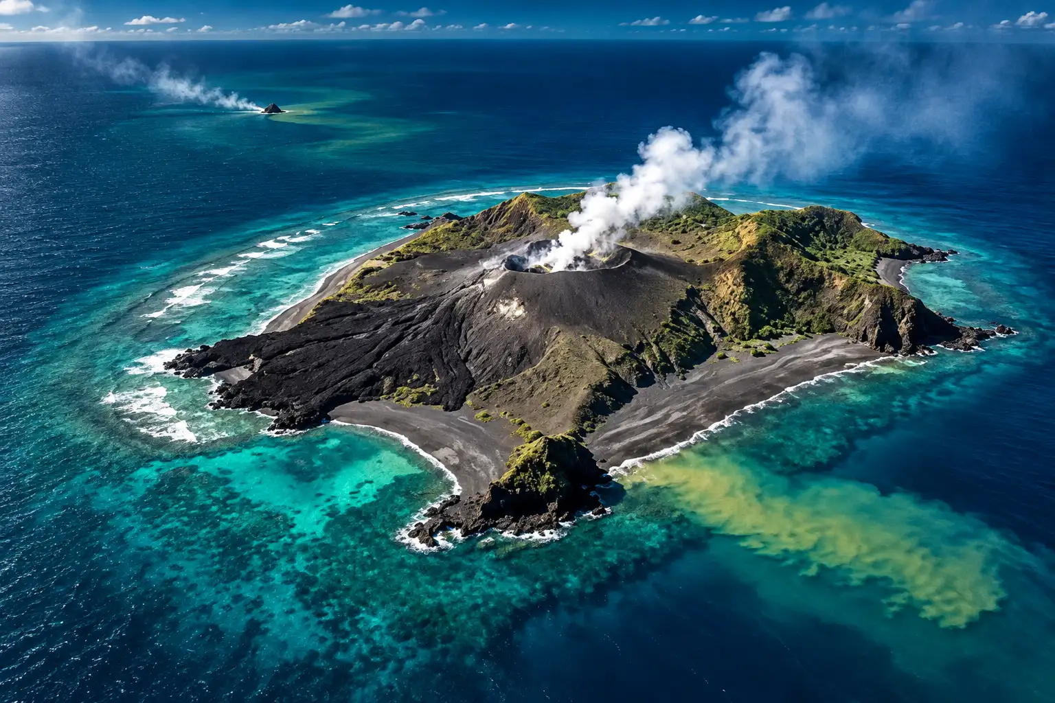
Home Reef is a mostly underwater volcano on the Tofua volcanic arc, at 18.992°S, 174.775°W, between Late Island and Lateiki in central Tonga. Heat sensors on NASA’s MODIS and VIIRS instruments showed the latest pulse beginning on 17 December 2025, after about five months of quiet, Plank said. Lava first ran east and south, then northwest, then north.
By early February, radar from DLR’s TerraSAR-X satellite showed the island had grown by nearly 8 hectares, or 20 acres, about the size of 15 American football fields, Plank said. Gas plumes rose from a vent about 100 metres across through that whole stretch. Landsat 8 and 9 images from 3 December 2025, 27 December 2025, and 28 January 2026 show the new lobes as they hardened.
THE FEBRUARY PULSE
- Start date: Thermal data put the eruptive phase at 17 December 2025, after about five months of quiet.
- New ground: TerraSAR-X measured nearly 8 hectares, about 20 acres, by early February 2026.
- Vent: Volcanic gas rose from a crater about 100 metres in diameter for the whole pulse.
- What followed: Tonga Geological Services reported the eruption had gone quiet from 1 April through 14 July 2026.
That quiet is the part the February satellite story could not see. In its 9-15 July 2026 weekly report, the Smithsonian Institution’s Global Volcanism Program said Tonga Geological Services found no volcanic activity was detected from 1 April through 14 July. Satellite images still showed small steam plumes, weak heat, and discolored water on 6 June, plus minor shoreline changes. The lava had stopped. The sea had not.
The 1984 Island Was Larger, and It Vanished
The Global Volcanism Program’s first confirmed eruption at Home Reef is 1852, with another in 1857. Then the place went quiet for 127 years. In March 1984 it produced a 12-kilometre eruption plume, a lot of floating pumice, and an island about 500 by 1,500 metres, with cliffs 30 to 50 metres high around a water-filled crater.
That island was already gone when mariners saw a new one form in 2006. An ASTER image from 18 November 2005 showed no land at the site. The 1984 ground had lasted years, not decades, and the catalog still calls those older islands ephemeral, meaning they appear after an eruption and then waves cut them down.
The 2006 island shrank on a clock scientists could finally measure. A yacht crew reported an island of about 1.77 square kilometres five days after the 7 August start. By 4 October, ASTER showed about 0.24 square kilometres. Landsat-7 on 7 April 2007 left only about 0.003 square kilometres. Field work in November 2008 found the remnant completely eroded to about 9-10 metres below sea level.
ISLANDS HOME REEF HAS ALREADY LOST
| Eruption | Land that formed | What the sea did next |
|---|---|---|
| March 1984 | About 500 by 1,500 metres, cliffs 30-50 metres, water-filled crater | No island on an 18 November 2005 ASTER image |
| August 2006 | About 0.24 square kilometres on 4 October; yacht had first reported about 1.77 square kilometres | About 0.003 square kilometres on 7 April 2007; gone by November 2008, 9-10 metres down |
| September 2022 to early 2026 | About 3 hectares at the start of the Sentinel-2 record, about 26 hectares on 15 February 2026 | Still above water through mid-July 2026, with minor shoreline changes after the lava stopped |
The current island is not the biggest Home Reef has ever built. It is the first in this century that has stayed up long enough for a field team to walk the problem in person.
Pumice From Home Reef Reached Australia
The older islands were easy for waves to unmake because so much of them was pumice, the light rock that traps gas as it cools. In 2006 the Global Volcanism Program recorded dacitic pumice rafts that drifted as far as Australia. The 1984 blast also threw a large volume of floating pumice into the South Pacific.
Those rafts are why a remote Tongan seamount shows up in shipping logs thousands of kilometres away. Porous rock rides the surface until it waterlogs or washes ashore, so an eruption that never threatens Vava’u can still foul hulls and beaches in Fiji and on Australia’s east coast. The 2022-2026 island is a different bet, because the thing holding it up is lava, not foam.
Shane Cronin Says Lava May Buy a Few Years
On 5-6 November 2025, Tonga’s Ministry of Lands, Survey, Planning and Natural Resources sent the first volcanology mission to the new island on the navy ship HMAF Ngahau Koula. The team included Professor Shane Cronin, Dr Barbara Martelli and Dr Jie Wu from the University of Auckland and the University of Otago, with Rennie Vaiomounga and Valeliano Tovi from Tonga Geological Services.
They found a solid base of lava flows with a cone on top, about 70 metres high and over 1 kilometre across, and a vent that had risen above the water. A drone survey, with NASA’s Jim Garvin, was meant to build the first detailed 3-D model. Gas measurements, the first ever made here, showed about 100 tonnes of sulphur dioxide a day, a sign magma was still close to the surface.
The gas measurements at this volcano, the first ever made, indicate release of ~100 tonne SO2 /day. This shows that magma is close to the surface and that the eruption is not yet over.
Tonga Ministry of Lands, Survey, Planning and Natural Resources, November 2025 field report
Cronin said the island is likely to survive a few years because of that strong lava base, and that with the vent now above water, later blasts could throw more ash. The sides already showed small landslides that could stir a local tsunami. If the eruption stayed at the scale seen so far, ash fall and tsunami hazard would likely stay within 10 kilometres of Home Reef, the mission said.
Plank’s 2025 study in Scientific Reports tracked the 2022-2024 phases from space and found vent migration due to erosion: each new vent opened toward the side the sea had just cut back. The volcano does not only add land. It keeps rebuilding on the wound the waves make.
How Big Is the Home Reef Island Now?
Copernicus Sentinel-2 data put the island at about 3 hectares in September 2022 and around 26 hectares on 15 February 2026, nearly nine times larger. That 26-hectare figure is the land area. A Tonga Geological Services overflight on 17 February 2026, two days after the Sentinel-2 scene, found the island about 70 metres high and more than 1 kilometre wide, the same height the November field team had logged, measured across an irregular lava outline rather than as a filled circle.
The European Union’s Copernicus programme posted the 3-to-26-hectare comparison on 15 March 2026, using a 15 February Sentinel-2 frame that still showed hot lava and a plume over the vent.
🌋 Home Reef in Tonga has been erupting intermittently since 2022.
🛰️ #CopernicusEU Sentinel-2 data show the island growing from ~3 to 26 hectares – nearly 9× larger.
Satellites track rapid volcanic changes, supporting hazard monitoring & safety.
🔗 https://t.co/CHoY2cM3rO pic.twitter.com/Gq1R5b3IAO
— Copernicus EU (@CopernicusEU) March 15, 2026
The February 2026 pulse is only the latest layer. NASA Earth Observatory’s Landsat record of the birth is more modest: after the seamount awoke on 10 September 2022, a new island rose above the water eleven hours later. Tonga Geological Services put it at 4,000 square metres, 1 acre, and 10 metres high on 14 September, then 24,000 square metres, 6 acres, by 20 September. Plank’s later mapping had the first phase at about 54,900 square metres, then growth south and east through 2023 and 2024 to more than 122,000 square metres, matching NASA’s 12.2 hectares, 30.1 acres, after those eruptions. A further 3.7 hectares arrived in December 2024-January 2025. The December 2025 pulse then added the nearly 8 hectares that became the 20-acre headline, taking the Sentinel-2 total to around 26 hectares.
HOW THE CURRENT ISLAND WAS BUILT
- 10 September 2022: Home Reef awakes; a new island is above water about eleven hours later.
- 20 September 2022: Tonga Geological Services puts the new land at 6 acres, 24,000 square metres.
- June 2024: Lava lifts the island from 8.9 hectares on 15 June to 11.7 hectares by 30 June.
- November 2025: The first field team finds a lava-based island about 70 metres high and over 1 kilometre across.
- 17 December 2025: A new lava pulse begins after about five months of quiet.
- Early February 2026: Plank measures nearly 8 hectares, about 20 acres, of new ground; Sentinel-2 on 15 February puts the whole island near 26 hectares.
- 1 April-14 July 2026: Tonga Geological Services detects no volcanic activity; satellites show minor shoreline changes.
From about 3 hectares to around 26 is a real gain. It is also still a speck, and the 2006 island had already proved that a larger footprint can vanish in two years if the rock is weak.
Pilots Got an Orange Alert in January
Home Reef sits about 25 kilometres southwest of Late Island, 22 kilometres northeast of Lateiki, and 75 kilometres northwest of Mo’unga’one. Tonga Geological Services has kept the alert for people on Vava’u and Ha’apai at Green, the lowest level, through the pulse. The people who had to move were pilots and captains.
In late January 2026, pilots and residents of Vava’u saw steam and gas rise higher. On 19 January a Fiji Airways ATR72-600 and a Lulutai Airlines Twin Otter captain reported white cloud to 10,000 feet near the Vava’u route. Tonga Geological Services raised the aviation color code to orange over possible ash. Mariners were told to stay at least 2 nautical miles, 3.7 kilometres, off the island. After the 17 February overflight the ship buffer was briefly 5 nautical miles, 9.2 kilometres.
THE ALERT STEPS TONGA POSTED
- Residents: Vava’u and Ha’apai stayed at Green, with Tonga Geological Services calling the risk to those communities low.
- Aviation: Color code went to orange in late January 2026, then down to yellow in early April and to green in the 21-27 May window.
- Ships: The keep-out ran from 2 nautical miles, 3.7 kilometres, in January, to 5 nautical miles on 17 February, then to 1 nautical mile, 1.8 kilometres, once the lava stopped.
- June 2025: An earlier blast in that year sent ash up to 12 kilometres, a reminder that this vent can still reach air routes when it turns explosive.
A 1 March 2026 Australian Navy pass still photographed gray gas-and-ash puffs over the crater, darker at the vent and whiter at the top. Those puffs did not show up in satellite volcanic-cloud monitors. By the May report, heat was persistently low on the MIROVA system, and the aviation code was back at green.
Hunga Tonga Is Why the Satellites Stay Pointed
Home Reef is a tame neighbor of Hunga Tonga-Hunga Ha’apai, which in 2022 drove a plume into the mesosphere. NASA Earth Observatory notes that the current Home Reef activity is much tamer and that officials put the risk to inhabited islands as low. The same November 2025 voyage that landed the Home Reef team found Hunga’s remnant islands being worn down by waves and Tofua still leaking more than 250 tonnes of sulphur dioxide a day, down from about 700 tonnes in October 2022.
Cornel de Ronde, a marine geologist at what is now Earth Sciences New Zealand, put the monitoring case in plain terms after Hunga: given what the world witnessed there, submarine volcanoes are worth watching, and satellites are among the best, quickest, and safest ways to do it. Home Reef is a test of that idea. There is no instrument hut on the lava. Landsat, Sentinel-2, TerraSAR-X, MODIS, VIIRS, and Tonga’s own notices are the record.
The water around the island often turns green-yellow because volcanic gas and fluid mix with seawater. NASA Earth Observatory, citing earlier work, says those superheated, acidic plumes can carry rock fragments and sulphur, and that they can show up before anything breaks the surface. NOAA oceanographer Sharon Walker has said hot, acidic plumes can harm marine organisms and can kill them. After the Nafanua eruption near American Samoa, dead animals were found across the crater floor. Iron in some volcanic jets can also feed plankton, so the same chemistry that stains the water can both wound and feed the patch of ocean around a new island.
Algae were already blooming in the seawater around Home Reef when the November team visited, next to rock that gas had begun to rot. Insects and birds can use new ground once it stays up. That is the hopeful half of Cronin’s few-year window. The other half is already in the July satellite frames: small fumaroles, a little heat, and a shoreline that has started to move without new lava to replace it.
The nearly 20 acres logged in February 2026 are real. So is the 170-year habit of taking that kind of gift back. For now the island is still there, about 70 metres high, on a lava base Cronin thought might last a few years, while Tonga Geological Services watches a quiet vent and a coastline the Pacific has only just begun to edit.

A CubeSat Will Age Whisky That Never Comes Home

A Charity Quote Cost Shia LaBeouf the FKA twigs NDA

Looker Turned a Model’s Body Into Ad Inventory

Infinity Ward Bets a Paid DMZ Will Stick This Time

Disney Sidesteps a Kimmel Renewal as Failla Cites Losses

How to Get Pre Boarding on Southwest – Skip the Line with These Tricks

False AI Intel Nearly Put US Crews on a Chinese Ship

Tim Cook’s $4.6 Trillion Apple Still Runs on One Phone

Dunes Air Sues Nora Fatehi Over Its Luxury Jet

OpenAI Posts a Navier-Stokes Proof Clay Has Not Touched
-
 TRAVEL3 years ago
How to Get Pre Boarding on Southwest – Skip the Line with These Tricks
-
 NEWS1 month ago
False AI Intel Nearly Put US Crews on a Chinese Ship
-
 BUSINESS2 months ago
Tim Cook’s $4.6 Trillion Apple Still Runs on One Phone
-
 ENTERTAINMENT1 month ago
Dunes Air Sues Nora Fatehi Over Its Luxury Jet
-
 NEWS1 month ago
OpenAI Posts a Navier-Stokes Proof Clay Has Not Touched
-

 LIFESTYLE3 years ago
How Often Do You Have to Change a Monkey’s Diaper? The Truth About Pet Monkeys
-

 NEWS1 month ago
Australia Treats Cloud Software Payments as Taxable Royalties
-

 LIFESTYLE3 years ago
How Long Does It Take for Armpit Hair to Grow? The Stages of Hair Growth and How to Shave It